
File:EU-Germany.svg

Size of this PNG preview of this SVG file: 713 × 600 pixels. Other resolutions: 285 × 240 pixels | 571 × 480 pixels | 913 × 768 pixels | 1,218 × 1,024 pixels | 2,435 × 2,048 pixels | 2,045 × 1,720 pixels.
Original file (SVG file, nominally 2,045 × 1,720 pixels, file size: 7.33 MB)
Summary
| Description |
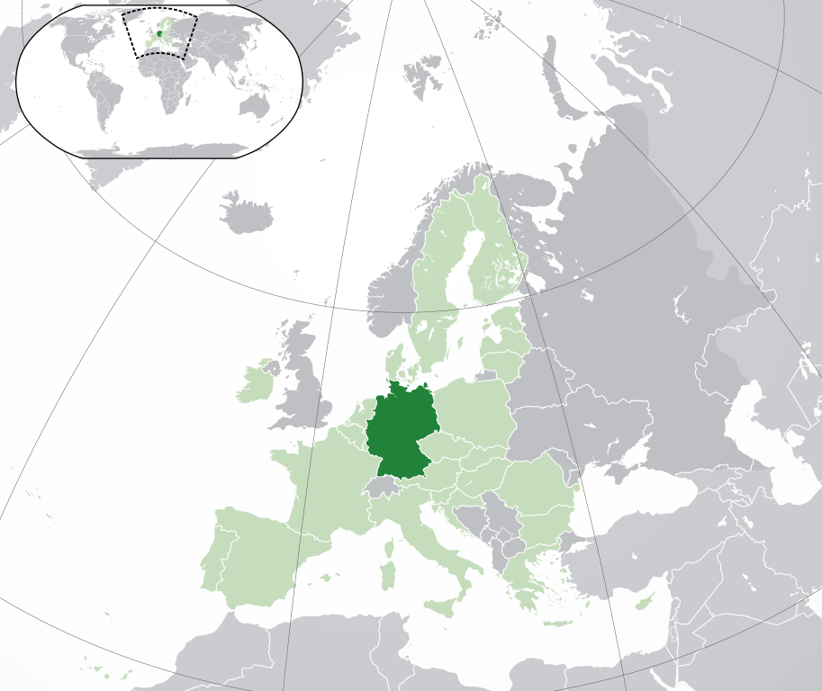
Italiano: (Verde) Germania.
(Verde chiaro) Unione europea (UE).
(Grigio) Europa.
(Grigio chiaro) Zone circostanti.
Vedi anche: English: (Dark-Green) Germany. (Light-Green) The rest of the European Union (EU). (Dark-gray) The rest of Europe. (Light-gray) The surrounding region.
See also: |
| SVG genesis | |
| Date | |
| Source | File:Location European nation states.svg |
| Author | NuclearVacuum |
| Other versions |
|


Licensing
I, the copyright holder of this work, hereby publish it under the following licenses:
This file is licensed under the Creative Commons Attribution-Share Alike 3.0 Unported license.
- You are free:
- to share – to copy, distribute and transmit the work
- to remix – to adapt the work
- Under the following conditions:
- attribution – You must give appropriate credit, provide a link to the license, and indicate if changes were made. You may do so in any reasonable manner, but not in any way that suggests the licensor endorses you or your use.
- share alike – If you remix, transform, or build upon the material, you must distribute your contributions under the same or compatible license as the original.

|
Permission is granted to copy, distribute and/or modify this document under the terms of the GNU Free Documentation License, Version 1.2 or any later version published by the Free Software Foundation; with no Invariant Sections, no Front-Cover Texts, and no Back-Cover Texts. A copy of the license is included in the section entitled GNU Free Documentation License. |
You may select the license of your choice.
File history
Click on a date/time to view the file as it appeared at that time.
| Date/Time | Thumbnail | Dimensions | User | Comment | |
|---|---|---|---|---|---|
| current | 04:37, 1 February 2020 | | 2,045 × 1,720 (7.33 MB) | Rob984 | UK and Gibraltar have left the EU. New base which includes all of Portugal's islands within frame, as well as Arctic Russian islands part of Europe. Also fixed Flevoland in the Netherlands. |
| 10:17, 16 June 2016 |  | 2,045 × 1,720 (6.97 MB) | Lord Obvious | Making German island dark instead of light green. | |
| 20:05, 19 April 2016 |  | 2,045 × 1,720 (6.96 MB) | Tubezlob | in the world map: Germany in green instead of light-green and Austria in light-green instead of green | |
| 09:29, 24 December 2015 |  | 2,045 × 1,720 (7.33 MB) | Nordwestern | Per original framework and Commons' rules. Agree with A2D2. | |
| 15:59, 18 March 2015 |  | 2,045 × 1,720 (7.38 MB) | Mapclean | Reverted to Leftcry's version, please go to your talk page | |
| 14:08, 21 February 2015 |  | 2,045 × 1,720 (2.62 MB) | VS6507 | Spain. Greece. Slovakia. Cyprus. Romania VETO | |
| 19:38, 16 November 2014 |  | 2,045 × 1,720 (7.38 MB) | Leftcry | Reverted to version as of 15:34, 6 August 2014 Please go to your talk page | |
| 16:30, 16 November 2014 |  | 2,045 × 1,720 (2.62 MB) | A2D2 | The map must show the original de-jure status with no breakaway regions, as it was originally created. An alternative map showing the de-facto status with breakaway regions needs to be created instead. | |
| 15:49, 16 November 2014 |  | 2,045 × 1,720 (7.38 MB) | A2D2 | Reverted to version as of 10:32, 13 July 2014 | |
| 15:34, 6 August 2014 |  | 2,045 × 1,720 (7.38 MB) | Rob984 | Sudan |
File usage
There are no pages that use this file.